Spain Volcanoes
-
Gran Canaria
-
Lanzarote
-
Lanzarote
-
Tenerife
-
Calatrava Volcanic Field
-
Tenerife
-
Tenerife
-
Tenerife
-
Tenerife
-
La Palma
-
Tenerife
-
Lanzarote
-
Lanzarote
-
Tenerife
-

Olot Volcanic Field
-

Gran Canaria
-
La Palma
-
La Palma
-
Lanzarote
-
Lanzarote
Spain has 8 Holocene volcanoes. Note that as a scientific organization we provide these listings for informational purposes only, with no international legal or policy implications. Volcanoes will be included on this list if they are within the boundaries of a country, on a shared boundary or area, in a remote territory, or within a maritime Exclusive Economic Zone. Bolded volcanoes have erupted within the past 20 years. Suggestions and data updates are always welcome ().
| Volcano Name | Location | Last Eruption | Primary Volcano Type |
|---|---|---|---|
| Calatrava Volcanic Field | Spain | 3600 BCE | Volcanic field |
| Fuerteventura | Canary Islands | Unknown - Evidence Credible | Fissure vent(s) |
| Gran Canaria | Canary Islands | 40 CE | Fissure vent(s) |
| Hierro | Canary Islands | 2012 CE | Shield |
| La Palma | Canary Islands | 2021 CE | Stratovolcano(es) |
| Lanzarote | Canary Islands | 1824 CE | Fissure vent(s) |
| Olot Volcanic Field | Spain | Unknown - Evidence Credible | Volcanic field |
| Tenerife | Canary Islands | 1909 CE | Stratovolcano |
Chronological listing of known Holocene eruptions (confirmed or uncertain) from volcanoes in Spain. Bolded eruptions indicate continuing activity.
| Volcano Name | Start Date | Stop Date | Certainty | VEI | Evidence |
|---|---|---|---|---|---|
| La Palma | 2021 Sep 19 | 2021 Dec 13 | Confirmed | 3 | Observations: Reported |
| Hierro | 2011 Oct 10 | 2012 Mar 5 | Confirmed | 2 | Observations: Reported |
| La Palma | 1971 Oct 26 | 1971 Nov 18 | Confirmed | 2 | Observations: Reported |
| La Palma | 1949 Jun 24 | 1949 Jul 30 | Confirmed | 2 | Observations: Reported |
| Tenerife | 1909 Nov 18 | 1909 Nov 27 | Confirmed | 2 | Observations: Reported |
| Lanzarote | 1824 Jul 31 | 1824 Oct 24 | Confirmed | 2 | Observations: Reported |
| Tenerife | 1798 Jun 9 | 1798 Sep 14 (?) | Confirmed | 3 | Observations: Reported |
| Hierro | [1793 May] | [1793 Jun] | Uncertain | ||
| Lanzarote | 1730 Sep 1 | 1736 Apr 16 | Confirmed | 3 | Observations: Reported |
| La Palma | 1712 Oct 9 | 1712 Dec 3 | Confirmed | 2 | Observations: Reported |
| Tenerife | 1706 May 5 | 1706 Jun 13 | Confirmed | 2 | Observations: Reported |
| Tenerife | 1704 Dec 31 | 1705 Mar 27 | Confirmed | 2 | Observations: Reported |
| Hierro | [1692] | [Unknown] | Uncertain | ||
| La Palma | 1677 Nov 17 | 1678 Jan 21 | Confirmed | 2 | Observations: Reported |
| Hierro | [1677] | [Unknown] | Uncertain | ||
| La Palma | 1646 Oct 2 | 1646 Dec 21 | Confirmed | 2 | Observations: Reported |
| La Palma | 1585 May 19 | 1585 Aug 10 | Confirmed | 2 | Observations: Reported |
| Tenerife | 1492 Aug 24 (in or before) | Unknown | Confirmed | Observations: Reported | |
| La Palma | 1481 ± 11 years | Unknown | Confirmed | 2 | Observations: Reported |
| Tenerife | [1444] | [Unknown] | Uncertain | ||
| Tenerife | [1396 ± 3 years] | [Unknown] | Uncertain | ||
| Tenerife | [1341] | [Unknown] | Uncertain | ||
| Tenerife | 1060 ± 100 years | Unknown | Confirmed | Isotopic: 14C (calibrated) | |
| La Palma | 0900 ± 100 years | Unknown | Confirmed | Isotopic: 14C (uncalibrated) | |
| Tenerife | 0800 ± 150 years | Unknown | Confirmed | 0 | Isotopic: 14C (calibrated) |
| Tenerife | 0700 (?) | Unknown | Confirmed | Correlation: Tephrochronology | |
| Lanzarote | 0700 ± 50 years | Unknown | Confirmed | Correlation: Magnetism | |
| Lanzarote | 0500 ± 50 years | Unknown | Confirmed | Correlation: Magnetism | |
| Tenerife | 0240 ± 150 years | Unknown | Confirmed | Isotopic: 14C (calibrated) | |
| Tenerife | 0190 (?) | Unknown | Confirmed | Correlation: Tephrochronology | |
| Tenerife | 0090 ± 75 years | Unknown | Confirmed | Isotopic: 14C (calibrated) | |
| Tenerife | 0040 (?) | Unknown | Confirmed | Isotopic: 14C (uncalibrated) | |
| Gran Canaria | 0040 ± 75 years | Unknown | Confirmed | Isotopic: 14C (calibrated) | |
| Tenerife | 0030 ± 150 years | Unknown | Confirmed | Isotopic: 14C (calibrated) | |
| Gran Canaria | 0010 ± 75 years | Unknown | Confirmed | Isotopic: 14C (calibrated) | |
| Tenerife | 0080 BCE ± 40 years | Unknown | Confirmed | 4 | Isotopic: 14C (calibrated) |
| La Palma | 0360 BCE ± 50 years | Unknown | Confirmed | Isotopic: 14C (uncalibrated) | |
| Tenerife | 0520 BCE (?) | Unknown | Confirmed | Isotopic: 14C (uncalibrated) | |
| Hierro | 0550 BCE ± 75 years | Unknown | Confirmed | Isotopic: 14C (uncalibrated) | |
| Gran Canaria | 0580 BCE ± 200 years | Unknown | Confirmed | Isotopic: 14C (calibrated) | |
| Tenerife | 0580 BCE ± 200 years | Unknown | Confirmed | Isotopic: 14C (calibrated) | |
| Gran Canaria | 0590 BCE ± 200 years | Unknown | Confirmed | Isotopic: 14C (calibrated) | |
| Gran Canaria | 0620 BCE ± 200 years | Unknown | Confirmed | Isotopic: 14C (calibrated) | |
| Tenerife | 0670 BCE ± 200 years | Unknown | Confirmed | Isotopic: 14C (calibrated) | |
| Gran Canaria | 0920 BCE ± 200 years | Unknown | Confirmed | Isotopic: 14C (calibrated) | |
| Hierro | 0950 BCE ± 150 years | Unknown | Confirmed | Isotopic: 14C (uncalibrated) | |
| Gran Canaria | 1010 BCE ± 100 years | Unknown | Confirmed | Isotopic: 14C (calibrated) | |
| Tenerife | 1050 BCE (?) | Unknown | Confirmed | Correlation: Tephrochronology | |
| Tenerife | 1150 BCE (?) | Unknown | Confirmed | Correlation: Tephrochronology | |
| Gran Canaria | 1180 BCE ± 50 years | Unknown | Confirmed | Isotopic: 14C (calibrated) | |
| Gran Canaria | 1250 BCE ± 200 years | Unknown | Confirmed | Isotopic: 14C (calibrated) | |
| La Palma | 1320 BCE ± 100 years | Unknown | Confirmed | Isotopic: 14C (uncalibrated) | |
| Tenerife | 1400 BCE (?) | Unknown | Confirmed | Correlation: Tephrochronology | |
| Tenerife | 1650 BCE (?) | Unknown | Confirmed | Correlation: Tephrochronology | |
| Tenerife | 1700 BCE (?) | Unknown | Confirmed | Correlation: Tephrochronology | |
| Tenerife | 1980 BCE ± 200 years | Unknown | Confirmed | Isotopic: 14C (calibrated) | |
| Tenerife | 2250 BCE (?) | Unknown | Confirmed | Correlation: Tephrochronology | |
| Tenerife | 2300 BCE (?) | Unknown | Confirmed | Correlation: Tephrochronology | |
| Tenerife | 2650 BCE (?) | Unknown | Confirmed | Correlation: Tephrochronology | |
| Tenerife | 2850 BCE (?) | Unknown | Confirmed | Correlation: Tephrochronology | |
| Tenerife | 3050 BCE (?) | Unknown | Confirmed | Correlation: Tephrochronology | |
| Tenerife | 3450 BCE (?) | Unknown | Confirmed | Correlation: Tephrochronology | |
| Tenerife | 3540 BCE ± 150 years | Unknown | Confirmed | Isotopic: 14C (calibrated) | |
| Calatrava Volcanic Field | 3600 BCE ± 500 years | Unknown | Confirmed | Isotopic: 14C (calibrated) | |
| Tenerife | 3750 BCE (?) | Unknown | Confirmed | Correlation: Tephrochronology | |
| Tenerife | 3960 BCE ± 300 years | Unknown | Confirmed | Isotopic: 14C (calibrated) | |
| La Palma | 4050 BCE ± 3000 years | Unknown | Confirmed | Isotopic: K/Ar | |
| Tenerife | 4200 BCE ± 100 years | Unknown | Confirmed | Isotopic: 14C (calibrated) | |
| Gran Canaria | 4630 BCE ± 75 years | Unknown | Confirmed | Isotopic: 14C (calibrated) | |
| Tenerife | 4650 BCE (?) | Unknown | Confirmed | Correlation: Tephrochronology | |
| Gran Canaria | 4670 BCE ± 75 years | Unknown | Confirmed | Isotopic: 14C (calibrated) | |
| Hierro | 4790 BCE (?) | Unknown | Confirmed | Isotopic: 14C (uncalibrated) | |
| La Palma | 4900 BCE ± 50 years | Unknown | Confirmed | Isotopic: 14C (uncalibrated) | |
| Tenerife | 5250 BCE (?) | Unknown | Confirmed | Correlation: Tephrochronology | |
| Tenerife | 5550 BCE ± 1500 years | Unknown | Confirmed | Correlation: Tephrochronology | |
| Tenerife | 5750 BCE (?) | Unknown | Confirmed | Correlation: Tephrochronology | |
| La Palma | 6050 BCE ± 1500 years | Unknown | Confirmed | Isotopic: K/Ar | |
| Tenerife | 6200 BCE ± 75 years | Unknown | Confirmed | Isotopic: 14C (calibrated) | |
| Tenerife | 6550 BCE (?) | Unknown | Confirmed | Correlation: Tephrochronology | |
| Tenerife | 6850 BCE (?) | Unknown | Confirmed | Correlation: Tephrochronology | |
| Tenerife | 7260 BCE ± 200 years | Unknown | Confirmed | Isotopic: 14C (calibrated) | |
| Tenerife | 7550 BCE (?) | Unknown | Confirmed | Correlation: Tephrochronology |
Spain has 2 Pleistocene volcanoes. Note that as a scientific organization we provide these listings for informational purposes only, with no international legal or policy implications. Volcanoes will be included on this list if they are within the boundaries of a country, on a shared boundary or area, in a remote territory, or within a maritime Exclusive Economic Zone. Suggestions and data updates are always welcome ().
| Volcano Name | Location | Primary Volcano Type |
|---|---|---|
| Cofrentes | Spain | Volcanic field |
| Islas Columbretes | Spain | Volcanic field |
There are 34 photos available for volcanoes in Spain.
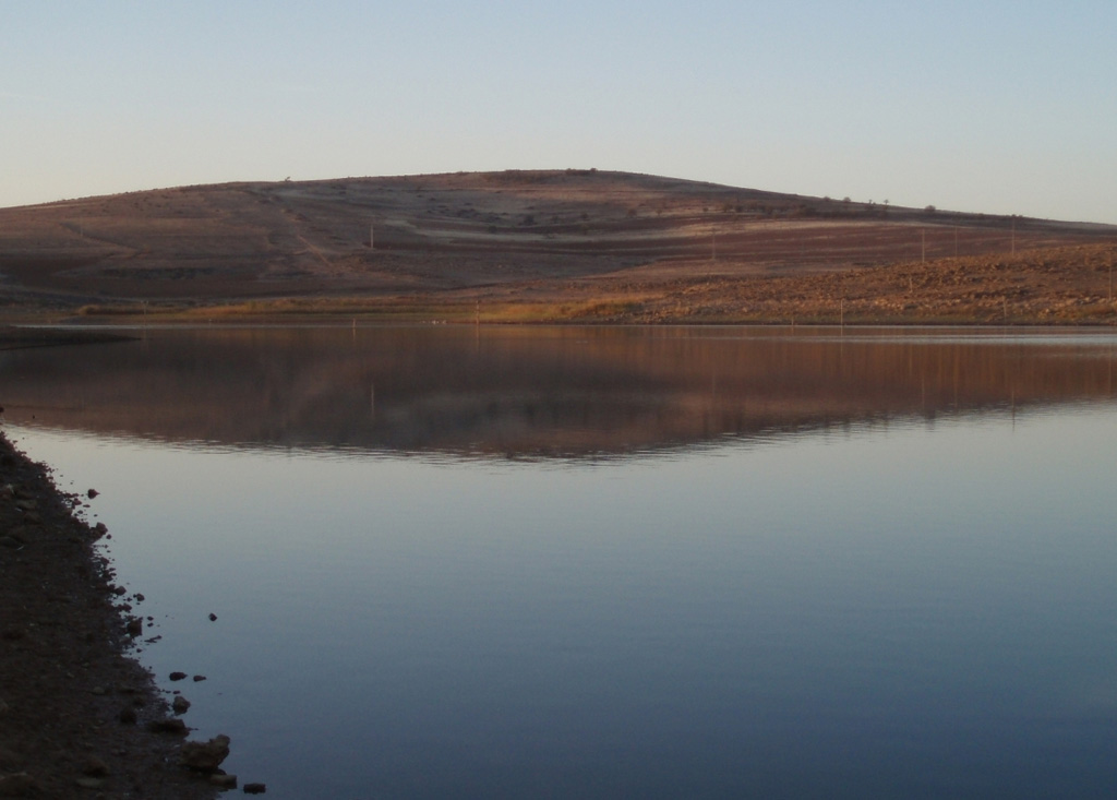
 Columba volcano, the youngest known vent of the dominantly Pliocene Calatrava Volcanic Field, rises above the Jabalón reservoir (foreground). The massive volcanic field covers an area of over 5,000 km2 and contains more than 300 cones, maars, and lava domes. This field is mostly of Pliocene or late-Pleistocene age, although late-stage phreatomagmatic activity at Columba volcano was dated at the mid-Holocene. Fumarolic activity was recorded in the Sierra de Valenzuela area during the 16th-18th centuries.
Photo by Rafael Becerra Ramírez, 2006 (Universidad de Castilla-La Mancha).
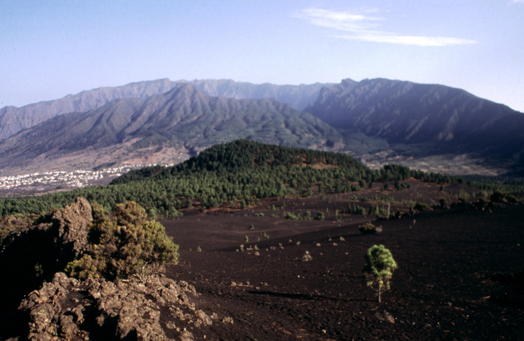
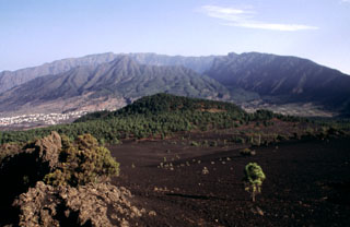
 The largely Miocene and Pliocene island of Gran Canaria in the middle of the Canary archipelago has been strongly eroded into steep-walled radial gorges called barrancos. Three major volcanic structures form the circular, arid island. Very young basaltic cones and lava flows of Holocene age are situated within a NW-trending zone cutting across the island; the youngest of these may be less than 1000 years old.
Copyrighted photo by Katia and Maurice Krafft, 1977.
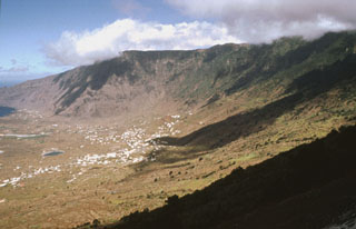
 The caldera rim of the Taburiente volcano, which makes up the northern section of the island of La Palma, is seen here from a lava flow field on the southern volcano, Cumbre Vieja. Bejenado volcano (left center) is located on the southern edge of the breached Taburiente caldera. Cumbre Nueva Ridge (right) was formed by a large-scale collapse. Cumbre Vieja is the most recently active volcanic center on the island, with numerous cones and lava flows.
Photo by Yasuo Miyabuchi, 1997 (Forestry and Forest Products Research Institute, Kyushu).
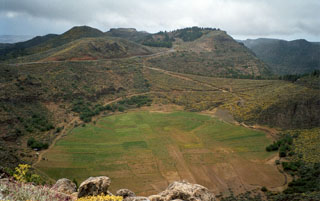 Agricultural field on the floor of Marteles Maar are seen in the foreground, with several cinder cones in the background. These are part of a group of Quaternary monogenetic volcanoes in northern Gran Canaria. Eruptions of Holocene age have been restricted to the northern, primarily north-eastern, part of the island, including at Las Isletas, a peninsula on the NE coast.
 Photo by Alexander Belousov, 2001 (Institute of Volcanology, Kamchatka, Russia).
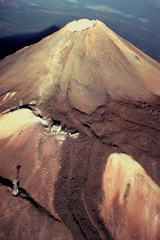
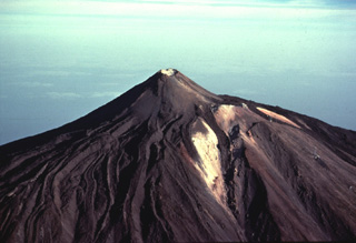
 The summit of Pico de Teide volcano towers 1700 m above the floor of Las Cañadas caldera, whose southern caldera wall forms the craggy cliffs at the top of the photo. Fresh-looking unvegetated lava flows descend 7 km from the summit of Pico de Teide to the caldera wall, spreading across the light-colored sediments (upper left) on the broad caldera floor.
Copyrighted photo by Katia and Maurice Krafft, 1977.
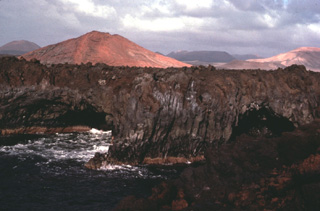 The 60-km-long island of Lanzarote at the NE end of the Canary Islands contains the largest concentration of youthful volcanism in the Canaries. Cinder cones and lava flows erupted along NE-SW-trending fissures in the Pleistocene and Holocene are found throughout the low-altitude arid island. The largest historical eruption of the Canary Islands took place during 1730-36, when long-term fissure-fed eruptions formed the Montañas del Fuego group of cinder cones and produced voluminous lava flows that covered about 200 km2.
 Copyrighted photo by Katia and Maurice Krafft, 1977.
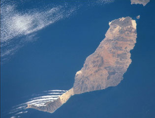 Pleistocene and Holocene cinder cones and lava flows cover large portions of Fuerteventura Island at the eastern end of the Canary Islands. As seen in this image taken from the International Space Station, the youngest lavas form the darker colored areas at the northern tip of the island, including the small Isla de Lobos off the tip of Fuerteventura, as well as in the south-central part of the arid island. The linear clouds off the southwest are not related to volcanic activity.
NASA International Space Station image ISS002-732-26, 2001 (http://eol.jsc.nasa.gov/).
 The massive El Hierro shield volcano is truncated by a large NW-facing escarpment, seen here, which formed as a result of gravitational collapse of the volcano. The steep-sided 1,500-m-high scarp towers above a low lava platform bordering 14-km-wide El Golfo Bay, which is barely visible at the extreme left. Holocene cones and flows are found both on the outer flanks and in the El Golfo depression. The latest subaerial eruption, during the 18th century, produced a lava flow from a cinder cone on the northwest side of El Golfo. A submarine eruption occurred in 2011-12 near the southern flank.
Photo by Yasuo Miyabuchi, 1997 (Forestry and Forest Products Research Institute, Kyushu).
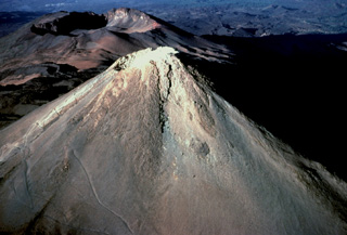
 Trachytic lava flows with prominent lateral levees descend from the summit of Pico de Teide volcano and spill over the rim of an older crater. The pylon at the lower left and the building at left-center mark the upper part of an aerial cable car line that provides access to the 3715-m-high summit of Pico de Teide, the highest peak in the Atlantic Ocean.
 Copyrighted photo by Katia and Maurice Krafft, 1977.
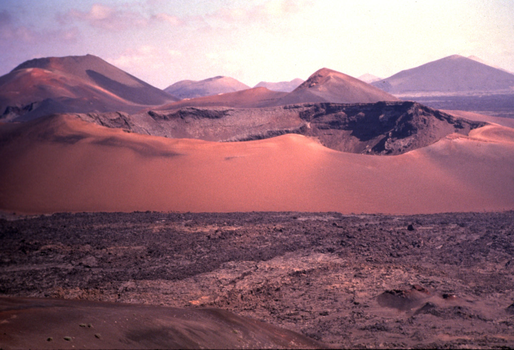
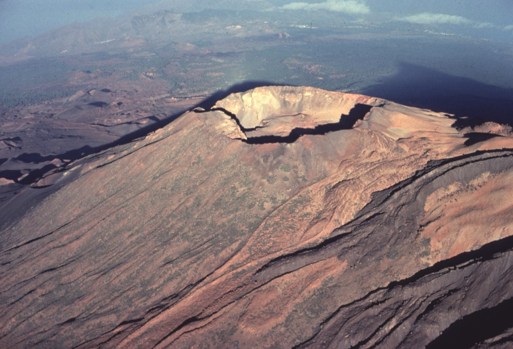
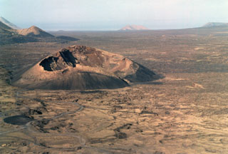
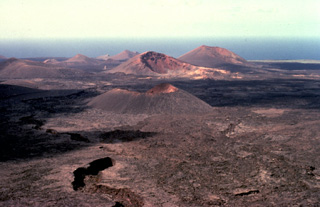
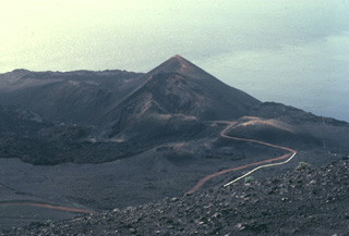
 Caldera del Corazoncillo (center), also known as Caldera de Fuencaliente, was active during a two-week period in September 1730, which initiated the 1730-36 Montañas del Fuego eruption on Lanzarote. The NE-SW-trending eruptive fissures were located slightly west of the low crest of the island, and most of the extensive lava flows reached the coast along a broad 20-km-wide front on the western side of the island. Only one lava flow reached the eastern coast.
 Copyrighted photo by Katia and Maurice Krafft, 1977.
 Cumbre Vieja, the southernmost of two large volcanoes forming the wedge-shaped island of La Palma, is one of the most active in the Canaries. The elongated volcano is oriented N-S and has been the site of numerous historical eruptions, many of which produced lava flows that descended steeply to the sea. Abundant cinder cones and craters line the crest of the volcano and dots its flanks. Historical eruptions, recorded since the 15th century, have produced mild explosive activity and lava flows that damaged populated areas.
 Copyrighted photo by Katia and Maurice Krafft, 1977.
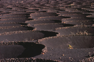
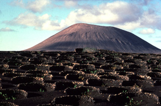 The circular stone-lined rings in the foreground of this Lanzarote cinder cone are the product of an innovative agricultural technique to enable crop growth on this arid, wind-swept island. Low stone walls constructed around small craterform depressions provide shelter from strong winds, permitting the growth of grape vines and fig trees.
Copyrighted photo by Katia and Maurice Krafft, 1977.
 The steep-walled Caldera de Taburiente is the most prominent feature of La Palma island. The caldera extends 10 km in a NE-SW direction and is breached to the sea on the SW side through a narrow notch at the left. Historical eruptions on La Palma have been restricted to a series of fissures and cones along a N-S-trending dorsal ridge extending to the southern tip of the island.
Copyrighted photo by Katia and Maurice Krafft, 1977.
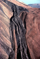 A dark-colored trachytic lava flow descends the flanks of Pico de Teide volcano on Tenerife Island in the Canary archipelago. The viscous obsidian-bearing lava flow displays steep-sided lateral levees. These define individual lobes that diverged around a high point on the surface of the flow. Another lava flow, one of many youthful flows erupted from Pico de Teide, forms the dark streak at the top center of the photo just below the skyline.
Copyrighted photo by Katia and Maurice Krafft, 1977.
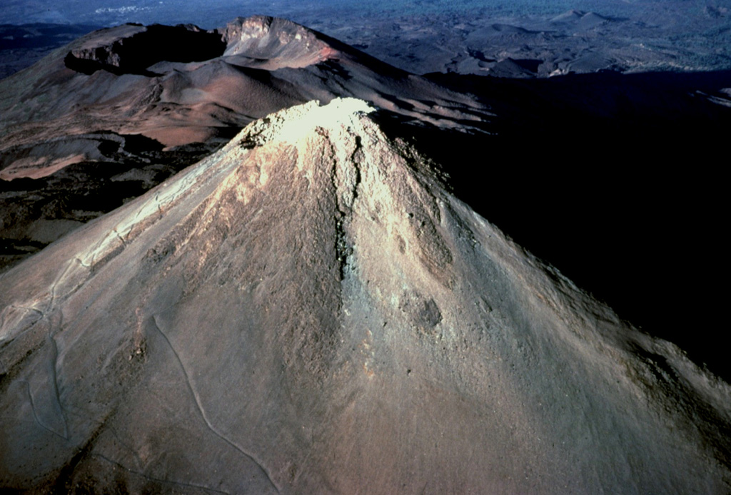
 The Caldera de los Cuervos (left center) was formed during the initial stage of the eruption during 1730 to 1736. Eruptions from a 13-15 km long NE-SW trending fissure formed more than 30 cones and produced voluminous lava flows that covered about 250 km2, reaching the western coast. A third of the farmland and numerous villages were buried in ash during this six-year long eruption.
 Photo by Raphaël Paris, 2001 (CNRS, Clermont-Ferrand).
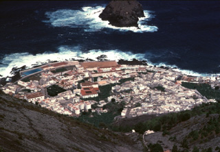 The town of Garachico on the northwestern coast of Tenerife Island occupies a lava delta created during an 18th-century eruption. The Garachico cinder cone, which was formed during the 1706 eruption, produced a 7-km-long lava flow that descended nearly 1400 m to the sea, destroying much of the village of Tanque as well as the town and port of Garachico. The Roque de Garachico island at the top of the photo predates the lava flow.
Copyrighted photo by Katia and Maurice Krafft, 1977.
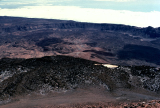 The arcuate rim of Las Cañadas caldera on Tenerife volcano in the Canary Islands rises in the distance above the flat-lying caldera floor. This view looks to the SE from the summit of Pico de Teide, a large stratovolcano constructed within the massive 10 x 17 km wide caldera. Dark-colored lava flows from Pico de Teide and other post-caldera cones mantle the caldera floor, which lies 300-m below the far caldera rim and 1700-m below the summit of Pico de Teide.
 Copyrighted photo by Katia and Maurice Krafft, 1977.
 Fresh-looking lava flows, seen here from the summit of Pico de Teide, descend towards Pico Viejo (top center) and diverge to the north and south along a broad saddle between the two volcanoes. A 750-m-wide crater truncates the summit of Pico Viejo, which was formed contemporaneously with Pico de Teide. These two stratovolcanoes were constructed within the 10 x 17 km wide Las Cañadas caldera, whose floor is visible in the distance.
Copyrighted photo by Katia and Maurice Krafft, 1977.
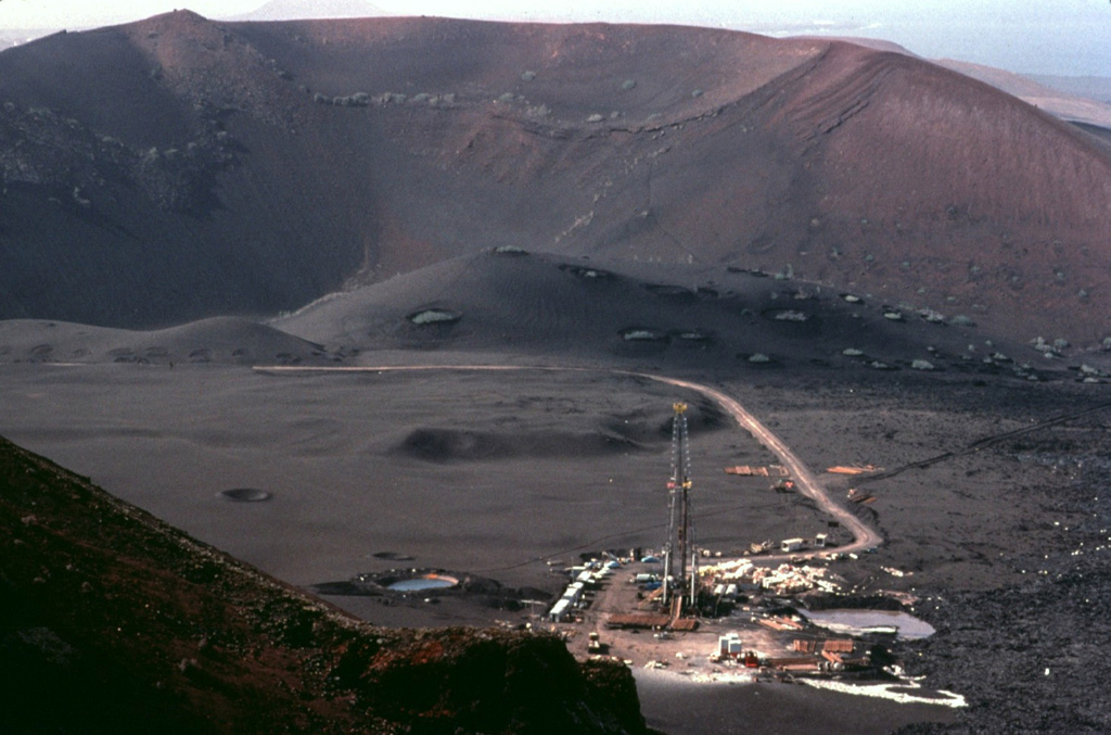
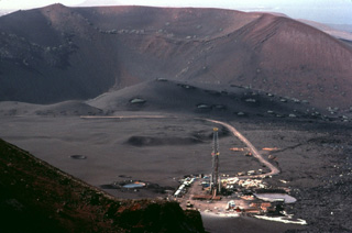 This geothermal drilling platform was part of an exploration program during the 1970's in Lanzarote's "Mountains of Fire." Residual heat from the 18th-century eruptions remains. Temperatures of 100 degrees centigrade were reached only a few cm below the surface, and a maximum temperature of 312 degrees was measured at a depth of 12 m.
Copyrighted photo by Katia and Maurice Krafft, 1977.
 Circular Caldera del Corazoncillo (center) on Lanzarote, also known as Caldera de Fuencaliente, was active during a two-week period in September 1730, at the beginning of the 1730-36 Montañas del Fuego eruption. Lava flows effused from NE-SW-trending fissures and numerous cones (background), and reached the western side of the island over a 20-km-wide front, covering an area of about 250 km2.
 Photo by Nicolau Wallenstein (Center of Volcanology, Azores University).
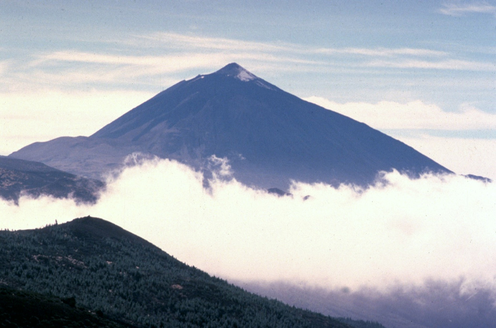
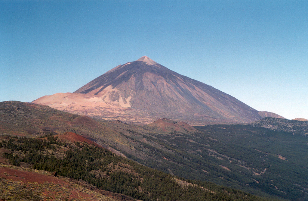
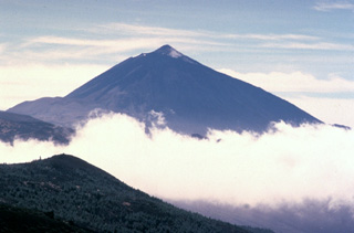 The 3715-m-high Teide stratovolcano, the highest peak in the Atlantic Ocean, dominates the island of Tenerife. Pico de Teide was constructed within the 10 x 17 km Las Cañadas caldera. The NE-trending Cordillera Dorsal volcanic massif joins the Las Cañadas volcano on the SW side of Tenerife with older volcanoes, creating the largest of the Canary Islands. Tenerife was observed in eruption by Christopher Columbus, and several other flank vents on the most active volcano of the Canary Islands have erupted during historical time.
Copyrighted photo by Katia and Maurice Krafft, 1977.
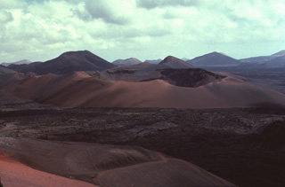
 The largest historical eruption of the Canary Islands took place from 1730 to 1736, when a NE-SW-trending fissure formed the Montañas del Fuego ("Mountains of Fire"). Voluminous lava flows covering 200 km2 reached the western coast, seen in the distance, along a broad, 20-km-wide front. The villages of Maretas and Santa Catalina were destroyed, along with the most fertile valleys and estates of the island, which was entirely evacuated. Numerous cinder cones such as these dot the lava field, much of which lies within Timanfaya National Park.
 Copyrighted photo by Katia and Maurice Krafft, 1977.
 Pico de Teide, the highest peak in the Atlantic Ocean, towers 1700 m above the floor of Las Cañadas caldera. The small nearly circular, 70-m-wide Caldereta crater truncates the summit of Pico de Teide. The prominent 750-m-wide summit crater of Pico Viejo, another post-caldera stratovolcano, appears to the WSW beyond the summit of Pico de Teide.
Copyrighted photo by Katia and Maurice Krafft, 1977.
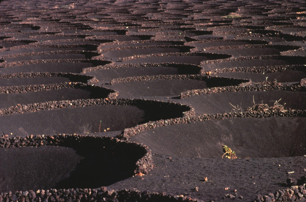
 This geometric pattern in 18th-century ashfall deposits at Lanzarote is a human adaptation to permit agricultural use of this barren, wind-swept terrain. Grape vines and fig trees planted in shallow depressions excavated in the extensive pyroclastic-fall deposits are surrounded by low circular walls of volcanic blocks and bombs. This concentrates moisture in the finer-grained center of the pits and partially shelters the plants from the severe winds that sweep across the volcanic plain.
Copyrighted photo by Katia and Maurice Krafft, 1977.
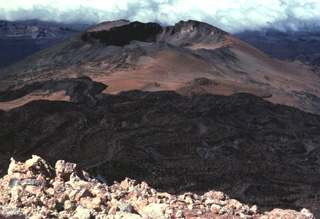
 A prominent crater caps Pico Viejo, the second largest stratovolcano constructed within the massive Las Cañadas caldera. The sharp-peaked summit of the largest post-caldera volcano, Pico de Teide, casts a shadow (upper right) on the floor of the caldera. Dark-colored trachytic lava flows with prominent lateral levees descend at the lower right from the summit of Pico de Teide. A chain of youthful cinder cones, some of which erupted during historical time, occupies the caldera floor beyond Pico Viejo at the left.
Copyrighted photo by Katia and Maurice Krafft, 1977.
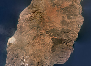 Fuerteventura island comprises the Northern, Central, and Southern Volcanic Complexes, with the Central complex shown in this November 2019 Planet Labs satellite image monthly mosaic (N is at the top; this image is approximately 42 km across). There was a period of significant erosion and quiescence before scoria cones and smaller lava flows were produced during the Quaternary through to recent times, including the darker lava flows and cones near the center of this image.
Satellite image courtesy of Planet Labs Inc., 2019 (https://www.planet.com/).
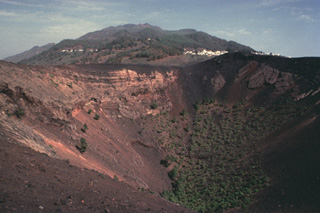
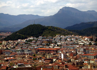 The forested Volcà Montolivet scoria cone rises above the city of Olot, as seen from the Volcà Montsacopa scoria cone to the NE. The cone is part of a large volcanic field named after the city and occupies the NE corner of Spain, south of the Pyrenees Mountains and about 90 km NNE of Barcelona. The latest dated eruption at Olot (also known as the Garrotxa volcanic field) occurred during the early Holocene and stratigraphic evidence suggests that more recent eruptions have occurred.
Photo by Puigalder (Wikimedia Commons).
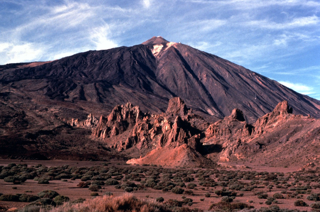
 Teide volcano, the highest point on the island of Tenerife, towers above the scarp of the massive Orotava landslide, which occurred about 600,000 years ago. The light-colored area on the eastern foot of the volcano (left) is covered by tephra deposits from the Plinian Montana Blanca eruption about 2,000 years ago. Teide was constructed within the 10 x 16 km wide Las Cañadas caldera on the SW side of Tenerife. The large triangular island is composed of a complex of overlapping stratovolcanoes that have remained active into historical time.
Photo by Alexander Belousov, 2001 (Institute of Volcanology, Kamchatka, Russia).
 Steep-sided Pico de Teide rises to 3715 m on SW Tenerife Island. The summit cone is capped by a small 70-m-wide crater and was constructed within a larger crater, whose outer slopes form the light-colored areas at the right. A dramatic complex of overlapping obsidian-bearing lava flows with prominent levees descends from the summit and drapes the western flanks of the volcano. The age of the lava flows is not known, but they represent some of the most recent eruptive activity on Tenerife.
Copyrighted photo by Katia and Maurice Krafft, 1977.
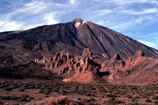 Pico de Teide towers above the Llanos de Ucanca plain on the floor of Las Cañadas caldera. The rocky spires in the foreground are eroded remains of intrusive phonolitic rocks of the Cañadas formation, predating formation of the caldera. Youthful dark-colored lava flows blanket the SW (left) side of Teide. The upper limit of the snowfield just below the summit of Teide marks the rim of the summit crater.
Copyrighted photo by Katia and Maurice Krafft, 1977.
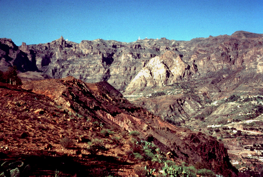
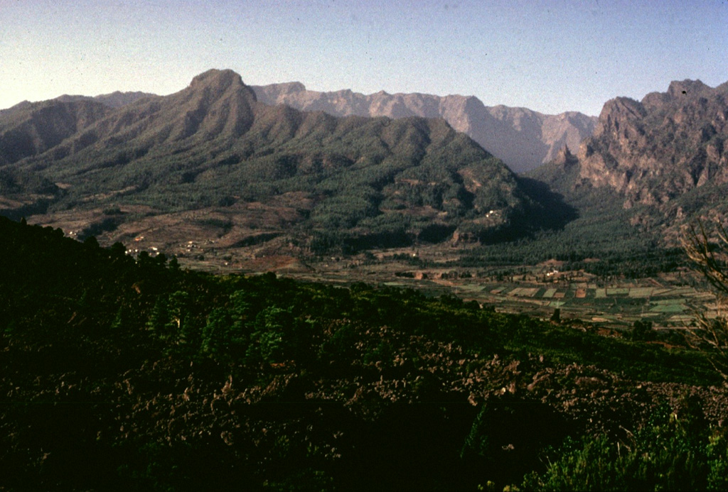
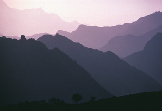 Dramatic lighting highlights the steep-sided ridges and deep canyons that dissect Gran Canaria Island. Extensive erosion has strongly modified the island, most of which is Miocene and Pliocene in age. Rejuvenation of volcanic activity during the Quaternary has produced basaltic cinder cones and lava flows, the most recent of which may be less than 1000 years old.
Copyrighted photo by Katia and Maurice Krafft, 1977.
 The dorsal spine of La Palma island is sprinkled with cinder cones, craters, and fissure vents formed during historical eruptions dating back to the 16th century. Many of these produced lava flows that reached the sea. The entire southern tip of the island was covered by lava flows during eruptions from the San Antonio (Fuencaliente) vent in 1678 and Teneguía cinder cone in 1971.
Copyrighted photo by Katia and Maurice Krafft, 1977.
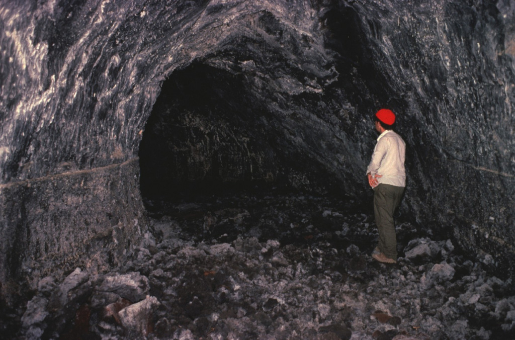
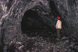 Volcanologist Maurice Krafft observes a lava tube on Lanzarote Island. Lava tubes provide an efficient means of transporting molten lava through subsurface channels that are thermally insulated from the surface. Many spectacular examples of lava tubes are found on Lanzarote, including the Ceuva de los Verdes lava-tube system, which extends more than 5 km from Volcán la Corona cinder cone to the Atlantic coast.
Copyrighted photo by Katia and Maurice Krafft, 1977.
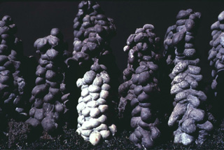 These unusual-looking lava stalagmites were formed when molten lava dripped from the ceiling of an active lava tube on Lanzarote Island. Corresponding lava stalactites hang from the ceiling of the lava tubes. The scale of these stalagmites is not stated, but may be a few tens of centimeters. Lava tubes are prominent features in the 1730-36 lava fields of Lanzarote.
Copyrighted photo by Katia and Maurice Krafft, 1977.
This is a compilation of Spain volcano information sources, such as official monitoring or other government agencies.
| Volcano Observatories | |
|---|---|
| Instituto Geográfico Nacional (IGN) | |
| - IGN Volcano Monitoring | |
| - IGN News, Monthly Reports, and Archives | |
| - IGN Civil Protection guide with Alert Levels | |
| Civil Protection Agencies | |
|---|---|
| Gobierno de Canaries | |
| 1-1-2 Canarias | |
| Gobierno de Canaries, Ministry of Health | |
| Volcanic Ash Advisory Center | |
|---|---|
| Toulouse Volcanic Ash Advisory Center (VAAC) Notices and Archive | |